For many years I'd been mulling over in the back of my mind various ways that optical ("lightbeam") communications could be accomplished over long distances. Years ago, I'd observed that even a modest, 2 AA-cell focused-beam flashlight could be easily seen over a distance of more than 30 miles (50km) and that sighting even the lowest-power Laser over similar distances was fairly trivial - even if holding a steady beam was not. Other than keeping such ideas in the back of my head, I never really did more that this - at least until the summer of 2006, when I ran across a web site that intrigued me, the "Modulated Light DX page" written by Chris Long and Mike Groth. While I'd been following the history and progress of such things all along, this and similar pages rekindled the intrigue, causing me to do additional research and I began to build things.
Working up to the distance...
Over the winter of 2006-2007 I spent some time building, refining, and rebuilding various circuits having to do with optical communications. Of particular interest to me were circuits used for detecting weak optical signals and it was those that I wanted to see if I could improve. After considerable experimentation, head-scratching, cogitation, and testing, I was finally able to come up with a fairly simple optical receiver circuit that was at least 10dB more sensitive than other voice-bandwidth circuits that were out there. Other experimentation was done on modulating light sources and the first serious attempt at this was building a PIC-based PWM (Pulse-Width Modulation) circuit followed, somewhat later, by a simpler current-linear modulator - both being approaches that seemed to work extremely well.
After this came the hard part: Actually assembling the mechanical assemblies that made up the optical transceivers. I decided to follow the field-proven Australian approach of using large, plastic, molded Fresnel lenses in conjunction with high-power LEDs for the source of light emissions with a second parallel lens and a photodiode for reception and the stated reasons for taking this approach seemed to me to be quite well thought-out and sound - both technically and practically. This led to the eventual construction of an optical transceiver that consisted of a pair of identical Fresnel lenses, each being 318 x 250mm (12.5" x 9.8") mounted side-by-side in a rigid, wooden enclosure comprising an optical transceiver with parallel transmit and receive "beams." In taking this approach, proper aiming of either the transmitter or receiver would guarantee that the other was already aimed - or very close to being properly aimed - requiring only a single piece of gear to be deployed with precision.
After completing this first transceiver, hastily I built a second transceiver to be used at the "other" end of test path. Constructed of foam-core posterboard, picture frames and inexpensive, flexible vinyl "full-page" magnifier Fresnel lenses, this transceiver used, for the optical emitter and transmitter assemblies, my original, roughly-repackaged prototype circuits. While it was neither pretty or capable of particularly high performance, it filled the need of being the "other" unit with which communications could be carried out for testing: After all, what good would a receiver be if there were no transmitters?
On March 31, 2007 we completed our first 2-way optical QSO with a path that crossed the Salt Lake Valley, a distance of about 24 km (15 miles.) We were pleased to note that our signals were extremely strong and, despite the fact that our optical path crossed directly over downtown Salt Lake City, they seemed to have 30-40dB signal-noise ratio - if you ignored some 120 Hz hum and the occasional "buzz" from an unseen, failing streetlight. We also noted a fair amount of amplitude scintillation, but this wasn't too surprising considering that the streetlights visible from our locations also seemed to shimmer being subject to the turbulence caused by the ever-present temperature inversion layer in the valley.
Bolstered by this success we conducted several other experiments over the next several months, continuing to improve and build more gear, gain experience, and refine our techniques. Finally, for August 18, 2007, we decided on a more ambitious goal: The spanning of a 107-mile optical path. By this time, I'd completed a third optical transceiver using a pair of larger (430mm x 404mm, or 16.9" x 15.9") Fresnel lenses, and it significantly out-performed the "posterboard" version that had been used earlier. On this occasion we were dismayed by the amount of haze in the air - the remnants of smoke that had blown into the area just that day from California wildfires. Ron, K7RJ and company (his wife Elaine, N7BDZ and Gordon, K7HFV) who went to the northern end of the path (near Willard Peak, north of Ogden, Utah) experienced even more trials, having had to retreat on three occasions from their chosen vantage point due to brief, but intense thunderstorms. Finally, just before midnight, a voice exchange was completed with some difficulty - despite the fact that they never could see the distant transmitter with the naked eye due to the combination of haze and light pollution - over this path, with the southern end (with Clint, KA7OEI and Tom, W7ETR) located near Mount Nebo, southeast of Payson, Utah.
Finding a longer path:
Following the successful 107-mile exchange we decided that it was time to try an even-greater distance. After staring at maps and poring over topographical data we found what we believed to be a 173-mile line-of-sight shot that seemed to provide reasonable accessibility at both ends. This path spanned the Great Salt Lake Desert - some of the flattest, desolate, and most remote land in the continental U.S. At the south end of this path was Swasey Peak, the tallest point in the House range, a series of mountains about 70 miles west of Delta, in west-central Utah. Because Gordon had hiked this peak on more than one occasion we were confident that this goal was quite attainable.
At the north end of the path was George Peak in the Raft River range, an obscure line of mountains that run east and west in the extreme northwest corner of Utah, just south of the Idaho boarder. None of us had ever been there before, but our research indicated that it should be possible to drive there using a high-clearance 4-wheel drive vehicle so, on August 25, 2007, Ron and Gordon piled into my Jeep (along with a 2nd spare tire swiped from Ron's Jeep as recommended by more than one account) and we headed north to investigate.
Getting there:
Following the Interstate highway nearly to the Idaho border, we turned west onto a state highway, following it as the road swung north into Idaho, passing the Raft River range, and we then turned off onto a gravel road to Standrod, Utah. In this small town (a spread-out collection of houses, really) we turned onto a county road that began to take us up canyons on the northern slope of the range. As we continued to climb, the road became rougher and we resorted to peering at maps and using our intuition to guide us onto the one road that would take us to the top of the mountain range.
 |
 |
Luckily, our guesses were correct and we soon found ourselves at the top of the ridge. Traveling for a short distance, we ran into a problem: The road stopped at a fence gate that was plastered with "No Trespassing" signs. At this point, we simply began to follow what looked like road that paralleled the fence only to discover, after traveling several hundred feet - and past a point at which we could safely turn around - that this "road" had degenerated into a rather precarious dirt path traversing a steep slope. After driving several hundred more feet, fighting all the while to keep the Jeep on the road and moving in a generally forward direction, the path leveled out once again and rejoined what appeared to be the main road. After a combination of both swearing at and praising deities we vowed that we would never travel on that "road" again and simply stay on what had appeared to have been the main road, regardless of what the signs on the gates said!
Looking for Swasey Peak:
Having passed these trials, we drove along the range's ridge top, looking to the south. On this day, the air was quite hazy - probably due to wildfires that were burning in California, and in the distance we could vaguely spot, with our naked eyes, the outline of a mountain range that we thought to be the House range: In comparing its outline and position with a computer-simulated view, it "looked" to be a fairly close match as best as we could guess.
Upon seeing this distant mountain we stopped to get a better look, but when we looked through binoculars or a telescope the distant outline seemed to disappear - only to reappear once again when viewed with the naked eye. We finally realized what was happening: Our eyes and brain are "wired" to look at objects, in part, by detecting their outlines, but in this case the haze reduced the contrast considerably. With the naked eye, the distant mountain was quite small but with the enlarged image in the binoculars and telescope the apparent contrast gradient around the object's outline was greatly diminished. The trick to being able to visualize the distant mountain turned out be keeping the binoculars moving as our eyes and brain are much more sensitive to slight changes in brightness of moving objects than stationary ones. After discovering this fact, we noticed with some amusement that the distant mountain seemed to vanish from sight once we stopped wiggling the binoculars only to magically reappear when we moved them again. For later analysis we also took pictures at this same location and noted the GPS coordinates.
Continuing onwards, we drove along the ridge toward George Peak. When we got near the GPS coordinates that I had marked for the peak we were somewhat disappointed - but not surprised: The highest spot in the neighborhood, the peak, was one of several gentle, nondescript hills that rose above the road only by a few 10's of feet. Stopping, we ate lunch, looked through binoculars and telescopes, took pictures, recorded GPS coordinates, and thought apprehensively about the return trip along the road.
Returning home:
Retracing our path - but not taking the "road" that had paralleled the fence line - we soon came to the gate that marked the boundary of the private land. While many of the markings were the same at this gate, we noticed another sign - one that had been missing from the other end of the road - indicating that this was, in fact, a public right-of-way plus the admonition that those traveling through must stay on the road. This sign seemed to register with what we thought we'd remembered about Utah laws governing the use of such roads and our initial interpretation of the county parcel maps: Always leave a gate the way you found it, and don't go off the road! With relief, we crossed this parcel with no difficulty and soon found ourselves at the other gate and in familiar territory.
Retracing our steps down the mountain we found ourselves hurtling along the state highway a bit more than an hour later - until I heard the unwelcome sound of a noisy tire. Quickly pulling over I discovered that a large rock that had embedded itself in the middle of the tread of a rear tire. After 45 minutes of changing the tire and bringing the spare up to full pressure, we were again underway - but with only one spare remaining...
Analyzing the path:
Upon returning home I was able to analyze the photographs that I had taken. Fortunately, my digital SLR camera takes pictures in "Raw" image mode, preserving the digital picture without loss caused by converting it to a lossy format like JPEG. Through considerable contrast enhancement, the "stacking" of several similar images using an astronomical photo processing program and making a comparison against computer-generated view I discovered that the faint outline that we'd seen was not Swasey Peak but was, in fact, a range that was about 25 miles (40km) closer - the Fish Springs mountains - a mere 150 or so miles (240km) away. Unnoticed (or invisible) at the time of our mountaintop visit was another small bump in the distance that was, in fact, Swasey Peak.
Interestingly, the first set of pictures were taken at a location that, according to the computer analysis, was barely line-of-sight with Swasey Peak. At the time of the site visit we had assumed that the just-visible mountain that we'd seen in the distance was Swasey Peak and that there was some sort of parallax error in the computer simulation, but analysis revealed that not only was the computer simulation correct in its positioning of the distant features, but also that the apparent height of Swasey Peak above the horizon was being enhanced by atmospheric refraction - a property that the program did not take into account: Figure 1 shows a comparison between the computer simulation and an actual photograph taken from this same location.
Building confidence - A retry of the 107-mile path:
Having verified to our satisfaction that we could not only get to the top of the Raft River mountains but also that we also had a line-of-sight path to Swasey Peak, we began to plan for our next adventure. Over the next several weeks we watched the weather and the air - but before we did this, we wanted to try our 107-mile path again in clearer weather to make sure that our gear was working, to gain more experience with its setup and operation, and to see how well it would work over a long optical path given reasonably good seeing conditions: If we had good success over a 107-mile path we felt confident that we should be able to manage a 173-mile path.
A few weeks later, on September 3, we got our chance: Taking advantage of clear weather just after a storm front had moved through the area we went back to our respective locations - Ron, Gordon and Elaine at Inspiration Point while I went (with Dale, WB7FID) back to the location near Mt. Nebo. This time, signal-to-noise ratios were 26dB better than before and voice was "armchair" copy. Over the several hours of experimentation we were able to transmit not only voice, but SSTV (Slow-Scan Television) images over the LED link - even switching over to using a "raw" Laser Pointer for one experiment and a Laser module collimated by an 8" reflector telescope in another.
With our success on the clear-weather 107-mile path we waited for our window to attempt the 173-mile path between Swasey and George Peak but in the following weeks we were dismayed by the appearance of bad weather and/or frequent haze - some of the latter resulting from the still-burning wildfires around the western U.S.
 |
 |
|
 |
 |
|
The 173-mile path - A first attempt:
In the days before the trip:
In preparation for this trip we knew that it likely that we would be able to communicate with each other via 2 meter simplex, but because of the distance we expected that signals would be weak. We had also arranged to meet with Chris, VK3AML on an IRLP node on a linked UHF repeater system operated by Dave, WA7GIE. To assure that we would be able to talk to each other directly via simplex as well as get into the UHF repeater system, each of us planned to take along both VHF and UHF portable beams. (It should be noted that cell telephone service at each site was spotty at best and due to the phones' running at full power and trying to communicate with the cell sites, battery life was only a few hours - even if the phones were simply left on and unused!)
After a week that had started out with bad weather we could see from the forecast that the upcoming weekend, Saturday the 15th of September, was likely to be clear, albeit windy, so we chose that date for our attempt. In preparation, Gordon went over to Ron's house on the prior Tuesday to repair his 2 meter "Walking Stick" beam - a portable antenna that he'd built years before, but had not gotten around to putting back into operational condition after several key pieces had gotten broken or lost. By the end of the evening the 2 meter beam was once again whole, but they had only started on construction of a 70cm version and were missing a few key raw materials. In the following days Gordon managed to obtain the remaining materials and mostly complete the antenna, but he had yet to do the final tuning.
Departure - September 15, 2007:
As Murphy dictated it wasn't until the morning of the scheduled departure that Gordon was able to get back with Ron to tune the antenna - a task that seemed to prove futile until it was realized that, for whatever reason, the VSWR bridge being used refused to read lower than 2.4:1 at UHF even on a known-good dummy load! Having already wasted most of an hour, a "guesstimate" was made on what seemed to be the best match, the final items were thrown into the vehicles, and Ron took off with Gordon and Brett N7KG under separate cover. At about 25 minutes into the trip I turned on the radio to hear Ron mention that he'd realized that he'd forgotten the digital audio recorder that was to record the output of the optical receiver. While the first inclination was to simply forget it, I volunteered to deliver to him one of mine, meeting him halfway, but then his wife, Elaine, N7BDZ appeared on the air and made the same offer: This latter offer was accepted, so Brett and Gordon turned around while Ron continued on to Orem to pick up Tom. After another 30 minutes or so a meeting occurred and Brett and Gordon were again underway with the recorder in-hand and Ron and Tom considerably ahead. At this point the south-going group was now two hours behind the original schedule with Ron and Tom 30 minutes ahead of Brett - but at least everyone in "Team Swasey" was headed in the right direction!
After loading my Jeep I headed over to Ron's house to pick up Elaine who was accompanying me to George Peak. By this time I'd replaced all of the tires and acquired a second spare of my own so, after throwing Elaine's gear into the car, we headed north. Meanwhile, Ron had stopped along US Highway 6 and waited for Brett and Gordon to catch up: Before too long, the two groups were reunited and heading toward Delta.
Omens:
Gordon wrote:
"We continued uneventfully, arriving in Delta a bit before 4
P.M. It
was somewhat too late for lunch and a bit early for dinner, but
something we could eat on our way to the trailhead sounded like a
time-saver. We could call it 'linner.' The only fast-food option seemed
to be McDonald's, so we chose our combo numbers with care.
"I had noted instructions to reach the trailhead from the Dave Hall
book, The
Hiker's Guide to Utah. Those
instructions, however, turned out to be almost useless as roads and
signage had changed over the years. We were supposed to look for a
turnoff 12 miles from Delta, but found none. Thanks to Ron's map
book... we turned onto a major gravel road at about 27 miles. This road
was signed for the "U-Dig" trilobite beds. This was clearly a different
approach than [the one that] John Parken and I had taken decades back,
as the older approach had followed the IPP DC power line
for the first part of its route.
"The route-finding rules seemed simple:
1. Stay on major gravel roads.
2. Take the choice that goes up.
3. If #2 isn't clear, go straight.
"As we looked for the turnoff, we began to sense a problem. According to our GPS receivers, the distance between us and our destination mountain was narrowing, but we still could not see it. In fact we could see hardly anything to the west. The vista faded into a gray haze of dust, sand, and smoke in some combination. This was not the ideal situation for a long-distance optical experiment!"
Before too long, Elaine and I were joined by Paul, W7PAH along with his son and grandson in their vehicle and we found ourselves traveling west along Utah Highway 30, now in sight of the Raft River range as well as the Goose Creek mountains that sit in Utah along the Nevada border. Being able to see over this distance, the density of the haze was increasingly apparent as a pall of dust. Because we were nearly there - and out of communications with the other group for the time being - we continued toward our destination.
"Team Swasey" begins its trek:
Gordon continues:
"We began to make out a hazy outline of a mountain when the magic of GPS told us we were within three miles of our destination. The mountain turned out to be, in fact, Swasey Peak. As it reached the base of the mountain, our road made a turn to the west and soon reached a four-way junction. After consulting with some hunters camped near the junction, we determined that a right turn would take us to our destination.
"The road ended in what might have been called a 'campground,' although there were no signs or facilities. The road split into a small grid of orthogonal roads ending at a sharp drop-off to the desert floor below [and the] GPS gave our elevation as 8062 feet. We were essentially at the trailhead. Ron and Tom found a short road or track that got us a few hundred yards closer to the mountain, so we drove to the end of it and declared it to be our trailhead.
"We prepared our packs for the hike up the mountain, dividing up the equipment and batteries necessary for the light communication. Ron had devised a way to carry the box with the optics and had built a small table that could be assembled on site and used to support the box on uneven ground.
"Brett decided his heavy tripod had enough more utility than my light one that he opted to carry his. Therefore we used mine to take the 'obligatory group picture' of the party with packs on. After that, the tripod was relegated to supporting a 'glow stick' that we hoped would guide us back to the vehicles after dark. Ron had thought to purchase several 'glow sticks,' chemical lights that, once activated, would send out light for most of the night. Using these to mark our trail seemed like a great idea."
 |
 |
 |
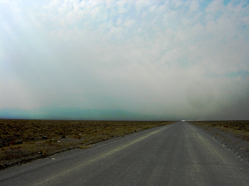
Just after crossing into Idaho, I headed west along a gravel road toward Standrod and then toward the south, up the increasingly-steep canyon road. After an hour or so of driving, we found ourselves in familiar territory on the ridge top of the Raft River mountains. As it turns out, there's no particular reason to set up at George Peak itself, as the mid-path blockage - the Newfoundland Mountains - a crescent-shaped range about 50 miles to the south - is cleared by traversing the ridgetop road to a point less than halfway between the point where the access road joins the ridge and the peak itself. Because of this, we stopped at a convenient wide spot on the road. Our now-commanding view revealed the extent of the haze: We could just make out features that were about 70-90 miles distant, but beyond this there seemed to be a veil of dust: Despite a degree of disappointment, we set up our gear, anyway, and waited to hear from the other end.
"What a royal pine in the..."
Gordon relates:
Waiting for dark:"Pack preparation took a little less than a half-hour and we started hiking at about 4:55. Instead of following a clear, easy trail, we found ourselves hunting for a route through thick growth of pinion and mountain mahogany. We would frequently go a few tens of yards and find our trail blocked by branches, then back up and try another possible path. The branches seemed particularly prone to grabbing antenna parts on the backs of packs, making the bearer try to figure out what was hanging him up in an area he could not see as he tried miscellaneous gyrations to try to get free. Progress (and frequently, retrogress) was slow.
"The route took us onto the summit ridge and we thought that once we attained the ridge, our troubles would be over. This was only partly true. Once we were near the ridge, the mountain mahogany became much less pervasive and there were longer clear stretches we could hike through. But as we progressed higher we encountered very steep slopes littered with loose gravel or loose soil and pine needles. As 7 P.M. approached, Ron and Tom, who were in the lead, picked a location for our anticipated light QSO. It was a rock outcropping that was right on the ridge, was clear of trees, and had an unobstructed view to the north. We were still about 400 vertical feet shy of the summit, but with sunset approaching it didn't appear we could reach the summit safely before dark.
"The ascent to the ridge was the hardest part of the hike for me. I saw what seemed to be a clear trail ascending and wondered why Brett had not taken it. But I gave it a try and found myself slipping down the scree faster than I could ascend. I gingerly picked my way over to Brett's route and had better luck.
"When Brett and I arrived at the site, Ron and Tom had already begun unpacking and setting up the optical transceiver. Ron's low table worked wonderfully and gave us a stable base for the large box with the optics. We had been worried about our ability to communicate with the other end. It turned out that Ron, on arrival, had given Clint a call on 147.54 simplex using just his handheld and a rubber duck. Clint came back almost immediately. Is a 173-mile simplex QSO on a rubber duck worth any points in the contest?"
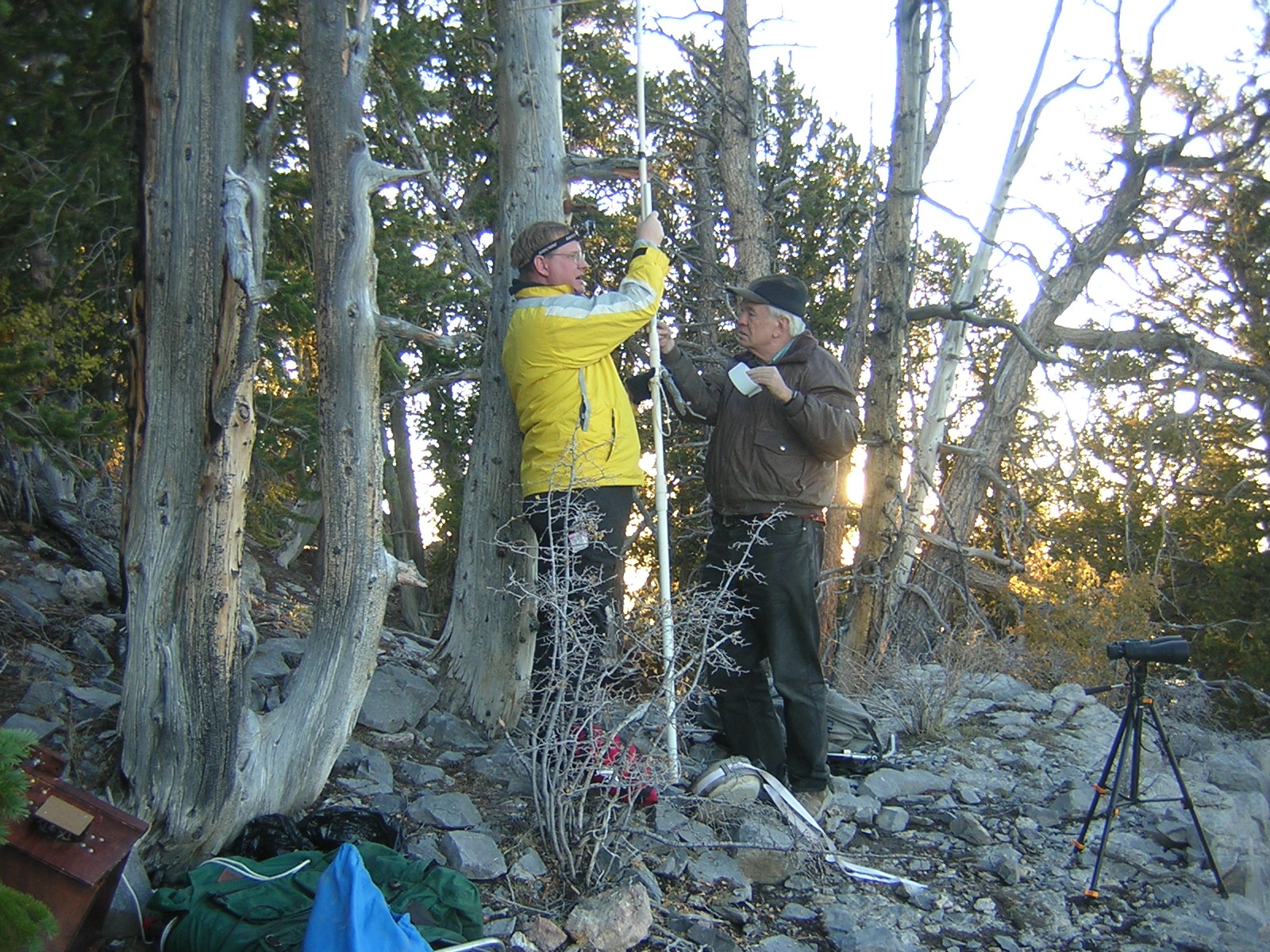
Upon making contact with Team Swasey, Brett and Gordon proceeded to set up their portable Yagi, improving their signal to us noticeably as compared to the rubber duck. For our end I had brought along a 3-element "tape measure" Yagi as it was extremely portable in that its elements could be folded together but very soon after setting up, we noticed a problem: Its flat elements seemed to catch the slightest puff of wind and would fold back, disturbing the elements' orientation and wrecking the antenna's directivity. Elaine disappeared over the ridge to the north in the direction of some Lodgepole pine trees and returned with some sticks that I taped to the upper half of the elements - a strategy that effectively solved the problem (see Figure 4.)
As there was still at least an hour before it would be dark enough to attempt any optical communications, we cooked and ate our dinner - a freeze-dried epicurean delight. We also took this time to demonstrate to Paul W7PAH, his son Scott KE7OMB and Scott's son, Brady, how the optical transceiver worked. In the meantime, Team Swasey decided to explore what other repeaters they could hit on 2 meters and were surprised to discover that they were able to get into the 146.76 repeater on Lake Mountain, over 90 miles away and behind several mountain ranges. While they were able to bring up an IRLP node through the repeater, they were surprised to discover that they'd not connected to the intended node and were somewhat dismayed when, despite numerous attempts, they were unable to successfully disconnect: Eventually they gave up, allowing the node to time itself out.
As the sun sank lower in the west a line of demarcation appeared across the its disk with the upper half being fairly clear but the lower half being much dimmer and redder, obscured by the airborne dust - an indicator of the true magnitude of the haze - see Figure 4. With the gathering darkness the temperature also dropped into the high 30's at the top of the Raft River range but the slight breeze that had been blowing when we arrived had all but ceased and the lower half of the Yagi's elements were gently oscillating due to the airfoil created by the curvature of their tape-measure elements.
Phlinging Photons with Phutility:
After the gloaming, we began our attempts to signal each other.
Gordon continues:
 |
 |
 |
 |
Ron's thoughts on the same:"Conveniently, the bearing to George Peak was only a few degrees off true north and Polaris was clearly visible, so it was easy to find the right direction to aim. We tried unsuccessfully for several hours to get light from one end to the other. We tried both directions and detected nothing either visually or electronically. At the northern end they tried not only the LED but also headlights, flashlights, and even a 'million candlepower' lamp. Brett and Tom thought they saw something several times, but it never correlated with the times when things were on or off on the other end. We attributed these sightings to headlights, campfires, and the like."
On that evening, despite several hours of trying, no signals could be acquired, nor could the distant light from the south end of the path be seen through an 8" reflector telescope set up at the south end."We did not hear a thing on the red band. It was totally quiet [but] I am quite sure we were pointing right. I slowly scanned back and forth and up and down over and over both when we were listening and when we were transmitting. My little table worked really well, I could smoothly move the box left and right and it was very stable. We did as Clint suggested and turned on the receiver when he transmitted just on a chance that it would hear something or respond to a laser flash, but we never heard the slightest change in the receiver’s noise."
As related by Gordon:
At the north end Paul and his kin departed and because they lived in northern Utah, they had only a two hour drive home. After packing the gear we drove most of the way down the mountain, stopping for the evening in a clearing amongst lodgepole pines that we'd noticed on the drive up because we had a 4-5 hour drive ahead of us and decided that it would be safer to delay until daylight. Throwing sleeping bags on the ground, we crashed there, under a starry sky, until the next morning."After about two hours of attempts, we decided to give up. We started packing up for the return trip a bit after 10 P.M. If the hike up had been frustrating, the hike back down was downright frightening. I guess there really was no great danger, but I was carefully considering each step before gingerly trying it on the loose gravel. I must have fallen at least a half-dozen times on the way back, and sometimes my feet would just slide out from under me again when I tried to get up.
"Ron and Brett were trying to keep the party together, an admirable goal. But they had their hands full between Tom going forward confidently and quickly in front, and me taking about five minutes for each ten feet of progress in the rear. Things started looking better after the initial steepest part was over.
"Often, all we could see of other members of the party was their lights. They were all distinctive and we learned quickly how to identify one another. Brett was using a red headlamp, I had a green LED mini-flashlight, Tom had a flashlight and a headlamp, both a bluish-white LED color, and Ron had a white headlamp.
"Of extreme value were the GPS 'bread crumb tracks' that constantly showed us how far we were away from our outbound route. Goodness knows our outbound route had not been one to recommend as a delightful hike, but at least we knew it was mostly passable and would eventually lead us back to the cars.
"We only found one of our glow sticks in addition to the one at the cars, but its sighting was a cause for some celebration. We got back to the campground a little after midnight with our bodies and equipment mostly intact. The night sky was gorgeous [and] we spent some time watching meteors and listening for [meteor] scatter bursts on an unused FM broadcast channel. Finally, we threw out sleeping bags and bedded down for the night."
In the morning, we packed up and headed the rest of the way down the mountain. Emerging from the canyon into the Raft River valley we couldn't help but notice that a dramatic change had occurred overnight: It appeared as though much of the "muck" that had been prevalent in the southern end of the path had moved northwards and was now enveloping much of northern Utah. To the south, "Team Swasey" awoke to a vista rather than a curtain of haze giving much of the party their first view of the surrounding desert. As you might have already guessed, both teams returned home safely after the adventure.
Lessons learned:
Obviously, we had to do more to determine beforehand if the air was likely to be clear enough for a reasonable chance of success. Of surprisingly little use was the weather forecast: While it was useful in telling us when not to try it, using the available data to determine if the air was going to be clear enough over such a long distance optical path was difficult. In hindsight, we should have realized the significance of the high winds along the desert - but there, too, was a contradiction: In the absence of wind, the clearing index is low and haze accumulates, while with too much wind, airborne dust becomes a problem.
After the fact it was realized that there was an important factor that had exacerbated the poor conditions. Several months earlier, the largest wildfire in Utah's recorded history had burned a large area to the south of Swasey Peak. The denuded landscape now fell victim to the wind's ability to raise large amounts of dust and ash into the air and in the weeks following the fire, sections the Interstate highway along the eastern edge of the "burn zone" had to be closed on several occasion when visibility dropped to less then a car length. Later, Gordon recalled Brett's mentioning that during the drive in, it seemed that much of the dust seemed to be coming from the south, the direction of the burn area.
After this attempt we also took more heed to the fact that it would be unlikely that good conditions were always going to coincide nicely with our schedules and occur on weekends. For future trips, we would keep an eye on the weather forecasts and mountaintop webcams - some of which could be used to provide a limited amount of information as to the clarity of the air over long distances. Perhaps the most significant change in strategy was that we should be prepared to go with short notice, taking immediate advantage of favorable conditions: This, of course, meant that it was likely that we'd have to take a day off work with little prior warning - something that was going to limit the number of those who would be able to go on the next trip.
Another thing that was learned was that despite the fact that the trail up and down Swasey was more difficult than expected, it was well within our abilities and prior experience and planning had adequately prepared those involved for the hardships that they encountered - namely, route-finding in the darkness. While it was somewhat of an encumbrance, the weight and bulk of the optical gear was easily manageable - especially when distributed amongst four people.
If at first you don't succeed...
(October 3, 2007)
As the days and weeks passed, we couldn't help but notice that the higher mountains had begun to show dustings of snow in the recent storms, offering warning that, before too long, the higher mountains would soon become inaccessible for the winter season. In preparation I bought a set of tire chains for my Jeep as it was expected that the shadowed, north-facing slopes of the Raft River mountains would have already begun accumulating their winter's snowpack. One unintended consequence of our plan of being prepared to leave with short notice was that it caused a certain amount of artificially-induced tension: There were several somewhat nervous discussions on whether or not the prevailing weather was good or bad for our plans, plus there was the realization that if we waited too long, the weather would close in and cancel plans for the year.
 |
 |
 |
 |
On the evening of October 2 we got together on a multi-way telephone call to decide our strategy: The weather looked to be pretty good - but there was a large storm system circling about in the pacific northwest that, it was predicted, would move into the area in 2 or 3 days, probably dumping enough snow in to the Raft River mountains to make them inaccessible by wheeled vehicle until the following summer. Also of some concern was the temperature which was predicted to drop into the mid 30's Fahrenheit overnight with a high into the low 60's in the day. This, coupled with the predicted "breezy" conditions, gave us worry about not only a recurrence of the previous attempt in which visibility was spoiled by airborne dust, but also the practical fact that it would be unpleasant to sit on an exposed ridge and hike down in the dark while facing fairly cool temperatures and high winds. Finally, after much deliberation, we decided to go for it.
Departure and arrival of Team Swasey:
According to Gordon:
"We had a telephone conference the night before the trip, and again the morning of our departure at about 7:20 A.M. to decide if we should really go. The 46-mph gusts predicted on Swasey were a bit daunting, but when all was considered, we decided to give it a try. We were proud of leaving Ron's house before 9:30, hours earlier than had been the case on September 15. This time the party consisted of Ron, K7RJ; Brett, N7KG; and the author, K7HFV. We all managed to fit into Brett's [Chevy] Avalanche... (Tom, W7ETR, who had been with us on the first trip was busy working and arranging to close on a house in Wyoming.) The 'team' at the other end of the path near George Peak would consist of just Clint, KA7OEI."
"The visibility looked fair, not great, but as we approached Delta, we could see Swasey peak way off to the west. More important, visibility to the north looked good. We stopped at a fast food joint in Delta and ate our lunch on the road as we continued to Swasey Peak, which came into clear view. We remembered last time at the turnoff we could not see the mountain. We talked to Clint a time or two on the cell phone to update him. As we suspected, we could not talk to him from about where we turned off the main highway till we were on the ridge at our final site. We were both in remote parts of the state with poor cell and ham radio repeater coverage. I suspect, had our mission been to talk to Clint on two meters from the base of Swasey peak, we may have been able to find some linkup, but getting up the mountain was far more pressing an issue and we knew we would have a 2 meter simplex path where it counted."
Because I didn't have to hike up a mountain, my departure time was a half-hour later than that of Team Swasey's - a schedule that would still allow ample time to get to my destination. As I sped north I could see that while there was some haze in the air, it looked more promising than it had during the previous attempt. I was also keeping an eye on the tops of the mountains and couldn't help but notice that the snowline seemed to be descending as I went north: I couldn't decide if this was simply an optical illusion, due to recently-cooler temperatures inhibiting the melt off, there having been more snow to begin with - or a combination of the three.
Before too long, I had a view of the Raft River range and I noticed, along the top and in the deeper couloirs, thin ribbons of snow: These remnants from the past weeks' storms, while not unexpected, made me glad that I'd brought a set of tire chains. Knowing how remote the destination was and how difficult any attempted rescue might be were I to run into trouble - either from a mechanical breakdown or due to a freak storm - I'd packed a week's rations of food and water, a camping stove, an extra change of clothes, a second pair of boots, several layers of coats and jackets, and two sleeping bags: If the worst happened, I might be miserable and unhappy, but I would be able to wait several days for rescue.
Soon, I found myself heading up One Mile canyon south of Standrod, Utah on the north slope of the range noting that the ground was mostly dry. It wasn't until above 7500 feet or so that I began to see larger patches of snow in the shadows - but the road was still in pretty good shape, albeit a bit muddy in a few spots. One of the features of this road is that it is quite rocky - a factor that can actually improve travelability in snowy and icy conditions.
The road continued up to a pass, took a sharp left turn, and continued upwards, hugging a west-facing slope: Up to this point the road is quite passable by ordinary 2-wheel drive vehicles, but it soon becomes a 4-wheel drive-only road. After traveling only a few hundred yards I met someone coming the other way, requiring me to back down the road 50 feet or so to find a spot wide enough to allow two vehicles to pass - an opportunity that I used to query the approaching driver about the road conditions above: He'd gone only as far as the "meadows" which he said were somewhat muddy - but that he'd heard from someone else up there that there may be some drifts on the road in the pines above that.
Soon, the road began to climb steeply along open, rocky ground on a northern face and it was along this portion that I first encountered enough snow to require a slight detour to avoid that which had drifted into the roadway. After topping the ridge and dropping slightly into the meadows, I experienced a little bit more snow and some mud, but I had little trouble. After crossing the meadows I started into the pines where a bit more snow drifted into the roadway, but it was rather packed and shallow so it posed no problem. Heading up the final slope to the highest ridge I passed a group of vehicles coming down - some of them towing trailers: One of the drivers mentioned that the road along the top was badly drifted, but the strategy of staying on the ridgetop itself and avoiding the road altogether had prevented problems. Continuing, I soon topped the ridge and drove along the road at about 12:30 in the afternoon. This road, although public, crosses a parcel of private ranch land - but this time the two gates bounding this section were open and just after exiting this portion of the road, I ran across the first bit of snow that caused a problem. After the first unsuccessful run across this patch, I backed up, put the chains on the front drive wheels, and successfully crossed broke through.
After driving a few hundred feet along the ridge top I noticed that the road below was, once again, clear so I decided to drop from the ridge back down to the road only to find myself firmly stuck in a snowdrift about three feet from the road and upon investigating, I noticed with chagrin that my Jeep had high-centered on snow. After about 90 minutes of crawling around under the car, removing as much snow as possible and unloading the vehicle to raise the frame, I placed a strip of plywood (brought along to form part of an equipment table) under the slipping front drive wheel: Soon, the spinning wheel gained purchase on the plywood, raising the car onto the surface of the snow, allowing the remaining pack to clear the undercarriage and the Jeep broke free of the snowbank. I then walked along the road, scouting for the best path and noted that there was a small patch of snow that I could not avoid. Returning to the Jeep I took a run at that patch, breaking through it and, with the vehicle still-unloaded, circled around the snowbank and parked on the ridge above where I'd been stuck.
 |
 |
 |
 |
 |
 |
At about this time, a rancher on horseback appeared from the south face of the mountain. Making a sweep of the range he was looking for the last of the cattle that he'd been running up there over the summer. I mentioned that I'd seen two head that, before I'd gotten stuck, were to the west of me - but were now about a half-mile to the east and up the hill. When asked about the gates being open on the fence he said that at this time of year all gates were opened to allow the cattle to roam freely so that they could seek shelter wherever they were - with the sorting out of whose cattle belonged to whom to be left for later. He was wondering what I was doing on a ridgetop at this time of year - especially because it was clear that I wasn't one of the throngs of bow-and-arrow hunters present on the mountain - so I explained to him, pointing at the barely-visible outline of the Fish Springs mountains in the distance. After a friendly 10 minute conversation he moseyed off in the direction of the cattle.
After changing into dry clothes and boots I spent the next half-hour lugging the previously-unloaded gear across the snowbank and reloading the car. Knowing that I would need to be able to retrace the path in darkness I set up a series of cairns to mark the route - particularly the spot where I'd originally chained up to leave the road for the ridgetop by crossing the small snowbank.
Traversing the snow-free top of the ridge I paralleled the road, eventually arriving at the very spot from which some pictures had been taken during the late August exploration trip. This place, although several miles east of George Peak itself was, by direct observation and examination of the pictures was known to have a line-of-sight path to Swasey Peak. What's more, having examined the photos, I already knew where Swasey Peak was in relation to the other topography so there was relatively little uncertainty as to where things had to be pointed. Finally, having already gotten stuck that day, I decided not to tempt fate by traversing the ridge any farther west than necessary!
I now began to unload the gear and set up.
Team Swasey begins the ascent:
In Gordon's words:
Meanwhile, back at at the Raft River mountains..."We stopped in Delta to procure some of the finest food that a McDonald's can provide, and then continued to the trailhead. We had talked about the possibility of hiking a different route, approaching the summit from the southeast rather than the northwest, particularly if the northern slope was snow-covered. We looked at the beginning of the alternate approach as we passed it on the road and concluded it started out quite passably although how the route got around a headwall was something not immediately obvious. We decided, though, to stick with the known [route] as there appeared to be no snow problem anywhere on the mountain.
"We reached the end of the road, packed our packs and started hiking just after 2 P.M., a full three hours earlier than on our September trip. The temperature was very comfortable, in the mid 70's. Our route involved getting to the summit ridge near a saddle northwest of the summit. We tried a different approach than the [expletives deleted] one we had used in September. We took a more northerly path, followed the rim of a deep canyon, and started climbing toward the ridge on the side of a draw furthest from the peak. We all agreed that this route, although a bit longer, was far more pleasant than its September counterpart. There were long, walkable strips, clear of mountain mahogany and pinion, and only occasionally did we have to duck down to pass under a tree branch or unsnag a pack from grabby branches.
"We left a glow-stick on a tree just short of the saddle, hoping it would help guide us down later on our descent in the dark. We had left another back at the truck. The saddle itself was quite dense with trees and took some maneuvering to cross. Just as we were about to start climbing toward the summit we heard a very loud roar that sounded like a cross between a hurricane and a steel foundry. Just as we began to wonder what sort of disastrous weather was striking, we spotted a black, military, supersonic jet rapidly receding west of us. No one recognized its model. (Clint later remarked, 'You probably weren't supposed to see that.')
"There was no getting around the fact that the ridge was very steep. We looked carefully for easier routes than we had found in September, and in a few cases found some segments that worked better, but the bulk of our route followed hints of a trail that we had found in September. The most difficult part was probably the ascent, over steep, loose gravel, leading to our September operating position. I did better than before, only having to be rescued once."
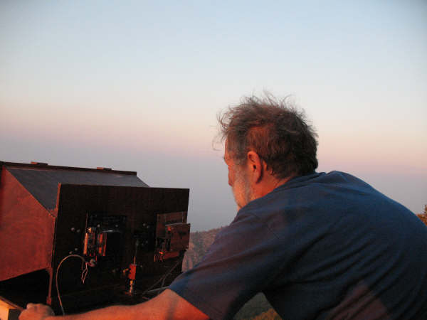
At the north end, I'd set up the telescope and radio in preparation for the arrival of Team Swasey at a place that had line-of-sight coverage to my location. Having nothing to do but wait I walked around, took a few pictures and then decided that having spent much of the day driving followed by several hours of digging the car out of the snowbank was likely to make someone hungry. For this late lunch I chose a freeze-dried entree - a wild rice and mushroom dish - rehydrated with boiling water. While the water was heating I rummaged around and discovered that I'd forgotten to bring any silverware so I ended up extruding the food from its plastic pouch: It was a messy method, but it worked (see Figure 6.)
While I was trying to eat my dinner, Ron called me on the radio.
Gordon continues:
 |
 |
 |
 |
Ron adds:"The hiking from this point was much easier and we soon came to a second likely position about 200 feet higher in elevation. It seemed to meet all the requirements: a drop off to the north, a reasonable amount of flat rock to set up on, and a location east of the ridge to shield us from expected west winds. Ron gave Clint a call on '54 simplex and got an answer, so we had at least a two-meter path over the 173-mile course. Clint reported the copy wasn't terribly good, but we could get through on the rubber duck antenna if we chose our position carefully.
"Should we try for something higher? We might have a better chance of success higher, but then we didn't look forward to a longer hike back in the dark, or having to operate in high winds on a cold night. It was between 4:30 and 5:00 with at least two hours left until sunset, so we decided to explore a little further without our packs. We thought that if the two-meter signal improved dramatically near the summit, the light path might also. If the two-meter signal didn't change much, then we would be more confident that the path from this position was as good as any.
"Uphill from this point, the going was relatively easy. We quickly reached the top of the immediate hill and saw that it was not the summit. We could see a flat face that was practically vertical and way above us. It looked quite daunting until we moved a few feet closer and saw that it was not as far as it first appeared and there was an easy way up. Brett and I headed on to the summit. Ron initially thought it would take too much time, but joined us when he saw how quickly we reached the top. The trip from our proposed operating site had taken less than 45 minutes.
"On top, we found a relatively new mailbox that served as the housing for the summit register. The last party seemed to have made an entry in late August. I logged us in with a one-sentence description of our purpose. Brett found an interesting message [what appeared to be 'XE5' written upside-down] that had been spelled out using small rocks. Ron tried contacting Clint on his H-T and concluded that the signal quality Clint was receiving was, if anything, worse than it had been at the lower operating position. We decided we would be happy with the lower site. Clint tried sending us a sunlight flash reflected by the mirror in his compass. Brett was sure he saw the flash several times and I saw a flash that seemed to correspond with Brett's sighting at least once."
"...[Having] dropped our stuff and [gone] to the summit... we did not find any better places to set up. The summit would have been beautiful, [as] it had a commanding view in every direction, but it was exposed and windy [and] we were concerned that at night it would be intolerable with the wind and possible cold. From the summit we talked to Clint on 2 meters and the signals were no better from the top than at our site [and] that made us a little more confident that our site was good enough.
"We tried flashing each other with mirrors. Brett and Gordon thought they each saw flash or two but I never saw a flash nor did Clint see one from us. The visibility was good, [but] not great, so we were not completely surprised that we couldn't see a flash."
Setting up:
Gordon continues:
"We returned to our site and started setting up. We tried the sunlight flash again, but were unable to spot anything reliably from Clint's direction. Ron started hooking up the optical transceiver and its associated electronics while Brett and I set up our 2-meter beam and established better-quality communication with Clint. Ron's table worked nicely on the bedrock and the adjustable-length legs made it so we could get the elevation within the range of the adjustment on the transceiver box itself. On the radio end of things, Brett and I lashed the WonderPole to a dead tree with cord and duct tape rather than using the rock pile and guy rope system we had used in September. We found that in addition to being able to work Clint, we could also hit the '62 repeater where we had a QSO with Brad, N7SWW, in North Ogden.
"During the setup we had heard the wind roaring strongly to the west of us, but our location, fortunately, provided good shelter. At this point, though, the wind began to abate. We hoped it would also take a break when we were ready to hike down. As it began to get dark, we looked carefully at the northern skyline to spot the pattern of mountains that would show us Clint's position.
"While we were looking we saw a bright, reddish light well above the horizon. [Audio clip, 2:58, MP3, 698kB] We guessed first it might be a plane's landing lights. However, it seemed too red and too stationary. It remained the brightest object in the sky for 5-10 seconds, then faded away over about one second. It had been in the general direction toward Clint, so we asked if he had seen it, but he had not. Before the evening was over we saw over a dozen of these strange, transient lights. They appeared sometimes singly and sometimes in pairs. They popped up at various azimuths, although the most common were northwest and slightly east of north. We never came up with a plausible explanation of their origin. We had seen nothing similar on the September trip to the same mountain.
 |
 |
 |
 |
Prior to sunset, I'd set several "optical beacons" along the ground in a line that extended several hundred feet in the direction of Swasey Peak. During the September attempt, we'd forgotten to lay out any visual references and once it got dark, the landmarks (distant mountains) disappeared, making it a bit less clear as to exactly where we should aim. These beacons were simply green LEDs connected to 9-volt batteries through resistors: While these LEDs were quite dim, they were easily visible in the darkness."Elaine, N7BDZ, had driven out on [Interstate]-80 to see if she could see anything from either end of this experiment. She calculated that our light path would cross the road very close to the 'tree' sculpture. When she came on the air, she had good communication with Clint on '54 simplex. We could hear her with a full quieting signal, but she could not hear us. She was able to see Clint's green laser pointer, but could see nothing from us. This might be explained by the fact that her distance to us was [slightly more than] her distance to Clint [which put us slightly below the visual horizon] plus the fact that we were running less than one watt to conserve batteries.
"The north star gave us a good reference for the right azimuth to Clint as his bearing was just 2-3 degrees west of north. It turned out that there was a cluster of lights (likely mercury vapor) visible on almost the right azimuth. Ron could make a preliminary receiver adjustment by peaking the receiver on the hum from the lights, then raising the azimuth to the skyline. We could hear a bit of our own signal owing to reflection from treetops near the lower edge of the beam."
As twilight passed we began in earnest to spot each other's lights. On my end, I used my 8" reflector telescope - along with a wide-angle eyepiece in a 2" mount - to try to spot the light from the far end. Team Swasey's spotting gear was more modest: Brett had brought along a large pair of tripod-mounted zoomable binoculars and there was a lightweight 60mm Meade refractor telescope to allow a second set of eyes to scan for light. As the evening progressed we threw whatever photon sources we had in each other's direction: In addition to the optical transceiver, I had onhand a 1/2 million candlepower spotlight as well as an assortment of red and green laser pointers - and I tried all of them - but nothing was spotted at the far end. At the Swasey end, the arsenal of light sources was smaller, but efforts to shine light to the north and be spotted were no less earnest.
After Elaine was able to spot my light sources I decided to travel about 3/4 of a mile west along the range (leaving behind the majority of the gear) to a location that was completely free of any obscuration by intervening terrain: Although the site that I had chosen should have had a line-of-sight path with Swasey Peak - especially with atmospheric refraction working in our favor - I tried this second location in the event that something odd was happening in that the supposed line-of-sight path was not, in fact, extant. After several minutes of signaling attempts (with lights) I gave up and headed back to the original site.
A final search for enlightenment:
Nearly ready to give up on this attempt I made yet another scan with the telescope while Ron moved the transmitter at the Swasey Peak end about, scanning both azimuth and elevation. After several minutes I caught a glimpse of what I thought was a flicker of light, just at the edge of perception, so I stopped moving the telescope and had Ron repeat the last several movements: The dim light came and went. Working more slowly, I had him move it back - and the light reappeared and I centered it in the telescope's field of view. To verify that I was, in fact, seeing what I hoped to see, Ron turned the light on and off while I relayed, via radio, when I saw it appear and disappear: I could hear an exclamation of relief from Brett and Gordon in the background audio when Ron's next transmission related that I was, in fact, seeing their light... Finally!
Audio clip:
- Seeing the light. This is an "open mic" recording that includes the moment at which the sighting of Team Swasey's light was verified. Unfortunately, background noise from the optical receiver makes it difficult to understand at times so a transcrption is provided below. (0:43, MP3, 252kB)
Transcription:Spending a few more minutes to visually peak the pointing of Ron's transmitter, I had him modulate it with a 1 kHz tone while I set my receive system in the "Audible S-Meter" mode and began scanning through the darkness. With only the dim, green LED beacons and the apparent pointing angle of the telescope, it was difficult to judge exactly where I should aim, but as I moved about, I could, amongst the thermal noise's deflection of the audible S-meter, discern a very slight peak in signal - but it was almost too small to be sure that I was really hearing it. I then had Ron shut off his transmitter while I turned mine on modulated with a 1 kHz tone while he relayed, via 2 meters, his audible S-meter: Because his receiver was already aimed in my direction, it was hoped that he might be able to hear me better than I could hear him.
Clint [via radio] Ok, hold - stop that. (pause) Hold it there, hold it there, hold it there! Uhmm, I can barely see it. (another pause) Uhmmm... Azimuth - I lost it... it's back. There it is. Elevation... Elevation...
Gordon: I can't see him - is anything happening?
Ron: Well I'm hearing something here, I...
Clint [via radio]: I'm not sending anything right now.
Ron: Clint?
Clint [via radio, interrupting Ron]: Turn it off.
Ron: I can't find the switch!
Clint [via radio]: Turn it off...
Ron: I can't find the [beep]ing switch!
Clint [via radio]: I need you to turn it off and on.
Ron: (There's a click) There, OK.
Clint [via radio]: Off... (click) On... (click) Off... (click) On
Ron: How about that!
(Sounds of jubilation!)
Note: Later analysis of the log recordings showed that the transmitter was in "variable tone mode" and a 1.4 kHz tone was inadvertently transmitted from Swasey on this occasion instead of the normal 1 kHz tone, greatly reducing the sensitivity of my S-meter during this particular phase of optical alignment and explaining why I found it so difficult to "see" his signal with it.
 |
 |
 |
 |
"With Clint looking in his scope, I slowly rocked the beam back and forth to tweak it in. I don't remember the sequence of testing, but Clint has devised a clever S-meter reporting scheme that makes it fairly easy to align the lights. By relaying a tone from the received over the 2 meter link, the person on the light transmitting end can swing their light back and forth and hear the tone change. By tweaking for the highest pitch tone, one can fairly easily align the transmitter. We went through this process and carefully acquired signals and aligned the pointing.
Listening to the S-meter tone relayed from
Ron's end, it took only a
few 10's of seconds before I heard a definite deflection
in the
pitch of the audible S-meter from his end, and hearing the meter
modulate when I keyed my own light verified what I was
hearing. After several more minutes of back-and-forth signal
peaking,
we managed to squeeze a few more dB out of each end of the link by
careful aiming and we were now ready to try an MCW (Modulated CW, or
Morse code)
exchange. Why use Morse? Simply put, it is an effective
digital narrowband communications scheme that requires a minimum amount
of
equipment - an important factor if you are carrying everything on your
back!
Ron continues:
As it turned out, Ron was able to copy the MCW that I was sending rather easily - even though it was quite weak. In turning the link around it became apparent that Ron was hearing me quite a bit better than I was hearing him, but I was still able to make out what he was sending amongst the noise. Having completed a 2-way Morse exchange, we then decided to try to see if it was at all possible to send voice back and forth. Talking very slowly, Ron was just able to hear my voice and tell what I was saying - albeit with some difficulty. In coming the other direction, however, I could tell only that a human voice was present in the background noise, but there was little hope in being able discern what was being said."The signals were very weak, we could only barely hear each others tones, but they were absolutely there. Since we could hear the tones we were able to make an official QSO exchange with each sending call letters and grid squares. We [sent] the code by turning on and off the LED [and because] the LED was always being modulated with a steady tone... [what] we heard in the speaker was the... [code] being sent. We did not get a tone because of simply detecting the presence or absence of light."
Segments of the recordings made during this event may be found farther down this web page.
According to Gordon:
After the fact, I reviewed the "open mic" audio recording from Swasey Peak and it turned out that Brett was questioning whether or not George Peak was the "bump" that he could see, or if it was a point beyond the bump that was, in fact George Peak: Early in the recording Brett reported seeing the flash of light in a point in space "above" where he interpreted George Peak to be according to the computer-simulated drawing."Somewhere in the exchange, Brett discovered that he really could see Clint's LED through his binoculars. He had initially aimed the binoculars based on a computer-simulated picture of what the skyline should look like. It turned out that the real bearing was just barely enough further west to be out of his field of view. The discrepancy may have been due to the picture's being based on the Swasey Peak summit rather than our spur-of-the-moment choice of operating position. A few other experiments were tried. Clint sent some pre-recorded slowscan [television, or SSTV] images that we recorded on a digital recorder from the receiver output. They would be decoded later..."
Now that the exchange had been completed I tried a few modifications to see if I could improve the receive sensitivity, including removing some of the photodiode masking that had been applied to reduce receiver beamwidth: It was difficult to tell if this actually helped or if conditions improved very slightly, but the MCW tone seemed to be slightly better in the back-and-forth exchanges that followed the adjustments - or was it just wishful thinking?
Finally, we decided that we'd done as much as we could with the high-power LEDs so, for Ron, I started playback of a recording of the theme song of the cult classic movie, Dark Star - a tune that Ron instantly recognized after the first few chords. After this, SSTV and a few more music and audio clips were sent. The entire exchange - both transmit and receive - had been recorded to .WAV format using portable digital audio recorders and using this format guaranteed that the audio would be losslessly recorded so that it could be analyzed later - including periods of constant tones that we had sent. These recordings could then be used to determine something about the signal-noise ratio of the signals that we were exchanging as well as the amount of scintillation caused by the atmospheric propagation over such a long distance.
Finishing the experiments with the LEDs we decided to see if we could span the distance with Lasers. On several previous occasions - such as our second 107 mile QSO - I had successfully used a Laser pointer module with my 8" reflector telescope. Even with its narrow beamwidth, aiming of the Laser was quite easily done as I simply removed the eyepiece and replaced it with the Laser module: Only a very small amount of tweaking of the telescope's elevation was required to peak the signal. On this occasion, however, no sign of the Laser was heard via the audible S-meter system or seen through the binoculars at Swasey. Ron tried going the other direction with his Laser pointer, but no evidence of signal was detected in that case, either.
Heading for home:
At this time - at about 10:15 PM - we decided that we were done, so our respective groups started tearing down and preparing to leave. I took a few more pictures and while doing this a gust of wind came up: As I lunged to keep the optical transceiver from sliding off the table, the tripod with my small point-and-shoot camera fell over, lens-first, destroying it: While annoyed, I'd realized that I could have saved only one piece of gear at a time - and I was thankful that it was not the expensive SLR that had been on the tripod at that moment! It took about an hour for me to tear down the equipment, pack, rearrange the gear in the car, and depart. At the time that I left, the wind was picking up a bit with the temperature in the low 30's F (near 0 C) but the sky was almost cloudless, providing a spectacular view of the heavens being completely free of light pollution and above much of the atmosphere.
While I was packing my gear, Team Swasey had yet another challenge ahead of them.
Gordon relates:
About the descent in the darkness, Ron said:"Getting down the ridge in the dark was probably at least as unpleasant as it had been on the September trip, but it helped to know from the previous experience that, even at a seeming snail's pace, it was possible to get back in a reasonable length of time. I think we all took a few spills on the section that is horribly steep over loose scree. We had to contend not only with the steepness and looseness, but also the wind. It had not granted our request to stay benign during our descent. Our packs sometimes acted as sails and, at one point, Brett was blown over while standing still. At least we could commend the weather service on their accurate prediction of the gusts.
"Following our GPS track from the uphill trip, we often found ourselves going in directions that seemed totally contrary to what common sense would have dictated. The trees were dense enough and the night dark enough that we could see little of the general terrain around us. I noticed that Polaris seemed to change direction regularly over a plus and minus 90-degree range. Without the GPS 'bread crumb' track we might well have wandered aimlessly until dawn.
"Once we were past the saddle, things went much better than on the September trip. We almost missed our glow stick, passing within 50 feet of it, but spotting it improved our confidence level considerably. Through the trees, Brett and Ron both had missing segments in their GPS tracks, but between the two we found most of our outbound path. We spotted the glow stick at the truck early enough for it to be helpful."
Note:"... It took about 20 minutes to pack everything up and head off the mountain. The trip down was equally difficult as the trip up [because] it was very steep coupled with being totally dark. We could see absolutely nothing without our flashlights and we would have been hopelessly lost without the GPS 'breadcrumb trail.' I fell a number of times, mostly from my feet slipping out from under me, but the trail was so steep that my butt didn't have far to fall. We had to push through the trees near the saddle and it was as miserable as we had feared. We were tired by then so it made it even worse... but, eventually we got through. When we got to the far side of the saddle away from the awful trees, we still had a long hike back to the car [and] we were tired and ready for it to be over, so the last leg of the trip seemed endless. When we got back to the car, we decided to drive back home instead of sleeping in the wind. We did stop a few times along the road to take naps. Maybe we should have stayed the rest of the night at the trailhead [and] next time, I would. I don't know when we got home, [but] I think it was around 6:00. I went to bed when we got home and went to work about noon."
It should be mentioned that even if Team Swasey did not have the facility of the GPS to guide them, they were prepared and equipped to wait until daylight to complete the return trip down the mountain if necessary. It should go without saying that relying on any single navigational system in such situations is not a good idea and that one should always have a backup plan!
 |
 |
By the time I got to Brigham City, though, I was ready for a few hours of sleep so I pulled in a rest area and closed my eyes for three hours. At 5 AM, I woke again and, ahead of the morning rush hour, and arrived home just after 6 AM - about the same time as Team Swasey. Before napping again, I decided to dash off a preliminary version of an account of the previous day's events while it was still fresh in my mind and while doing so, I heard Brett appear on a local 2 meter repeater reporting success in both the lightbeam communications and a safe return home by all team members.
Afterthoughts:
Weather:
Initially, there was some concern about the weather conditions: The forecast seemed unclear as to whether or not the Raft River range would get rain and/or snow the following morning (October 4) and I really did not want to get caught in an early-winter storm atop a remote mountaintop - even if I was prepared for it!
Ron expressed it this way:
"The week or so before the event, the weather was pretty bad. We had had a big snowstorm that actually came down into the valley. Nothing looked good about the weather [and] I was getting discouraged and then I started to fret about the prospects of going up on a mountain in the awful cold and wind and have to be able to stay warm enough to operate equipment and make technical decisions... My fingers and toes were numb just thinking about it. Also, I thought about the steep hike down the mountain in the cold and dark and all the things that could go wrong and it started to get to me. For a week before we went, I really was stressed [and] I let it get to me in a big way. I was disappointed in my attitude because I just love these sorts of adventures, they are a wonderful mix of a fun outing and technology. I was wanting someone to decide that we shouldn't go, but, fortunately, everyone had a much more realistic view and realized that the weather was not going to be that bad, and if it really turned bad, we'd simply come home. Thank goodness for leveler heads!"
About the "seeing conditions":
In retrospect, we realized that while the air was fairly clear during this expedition, it has to be extremely clear to guarantee good visibility over such a long path. In looking at our photographs from the August 25 trip and comparing them with those taken on October 3 (see the photos in Figure 10) we realized that the clarity along the overall path was about the same - although the density of the haze seemed to be more uniform during the latter event: In looking out across the distance, it looked to be less hazy on October 3 than it had been during our exploration trip in August, but the photographs reveal about the same amount of obscuration of detail in each case. The exact cause of the haze is unknown, but it is suspected that, as before, some of it was due to windborne dust - plus some smoke from still-burning California wildfires.
The photos in Figure 10 show what was being seen at the time and in each case, the insets contain both computer-generated simulations of the scenery showing the locations of the opposite end of the path in addition to contrast-enhanced portions of the image to bring out subtle details. As it turns out, on October 3 neither end was very visible with the naked eye and it was only through extreme contrast exaggeration of the original (non-JPEG!) digital images that details of the far end were even visible. (The insets contain contrast-enhanced images from raw imager files. In addition, the inset images taken of Swasey Peak contain at least five images having been "stacked" using an astronomical image-processing program to further reduce noise.)
Is it a record?
While the "undisputed" record for a 2-way, direct optical ground-to-ground optical communication is still a 1894 heliograph exchange of just over 183 miles, this is believed to be the longest-distance all-electronic 2-way ground-to-ground based communications using only "gray matter DSP" and not involving any sort of special, narrowband technique, weighing in at just over 173 miles. It is unfortunate that the clarity of the air prevented a 2-way voice exchange but it is expected that further enhancement of the gear plus better conditions will, some day, allow such a communications to be completed.
Additional comments:
Every time we have gone afield with the optical gear we gain both experience and insight as to how to improve our operation. In my opinion, our past outings had given us just enough experience with the equipment and the art to have lead to the success of this adventure and, as with any complicated endeavor, one cannot have too much practice.
This isn't to say that things can't be improved: In discussions since this event, a few things have been brought up:
- Some sort of sighting system. This could be as simple as a "sighting tube" or a pair of posts that function like a gunsight. While I've considered adding this from the beginning, it's hard to decide exactly how useful or practical it might be. In this case the distant LEDs were too dim to be seen with the naked eye, so any simple sighting system would have been useless for direct observation of the light from the far end: It was the electronic aiming system (plus the large telescope) that provided the critical aiming. A sighting tube may be useful in referencing known objects (distant lights, stars, etc.) to provide an approximate point, however. What is useful is the fact that one can usually see the beam being emitted from the transmitter due to Rayleigh and dust scattering - and this can provide an aiming aid.
- We are still trying to determine the reason for the disparity in the signal levels in the two directions. It is known that the optical transceiver used at Swasey has about 77% of the luminous flux output of the optical transceiver used at the Raft River end - a difference that correlates to a decrease of about 2.3dB of audio recovery. It does seem, however, that the majority difference between the two ends was due to the receiver used at the north end having slightly worse noise performance than the one used at the south end.
- It should be possible to bring the performance of both transceivers up to par with each other by further optimization of the optics - notably a precise modification of the secondary lens in the transmitter used at Swasey Peak.
- It should also be possible to extract a few more dB of receiver performance out of both receivers through the use of careful component selection and design refinement.
Analysis of the received signals:
Because waveform-accurate (non-compressed) digital recordings were made, it was possible to go back and analyze what was recorded at each end to glean more information out of the received signals than that which could possibly have been divined at the time of the event. Of particular interest to us is the amount of scintillation that was present on the received signal and, somewhat related, the average signal-noise ratio.
Scintillation:
 |
 |
Scintillation manifests itself as variation in the strength of the received signal - a result of light's traveling through an imperfect atmosphere. Scintillation can be caused by a number of factors, including:
- Variations in the refractive index of the atmosphere. Most of this is due to "bubbles" of air of different temperatures moving about in free space. Because air of different temperature has different densities - and because the refraction caused by the air is related to its density - light traveling through these "pockets" is "bent" very slightly.
- Scintillation due to coherence resulting from the very small subtended angle of the distant light source - a phenomenon referred to as "local coherence." At large distances, the small apparent size of the distant light source can, for all practical purposes, be considered to be a point source. With such narrow angles, even noncoherent light can "temporarily" achieve a degree of coherence - a property that can subject it to the same type of constructive/destructive interference observed when a coherent light source (e.g. a Laser) is used.
For our experiments we chose amplitude modulation as it is both simple to implement and very efficient in terms of minimizing receive system bandwidth and maximizing sensitivity - plus it lends itself to being able to measure the scintillation appearing on the received signals. During our testing our transmissions included sections of constant-amplitude, precise-frequency tones, something done specifically to provide a reference for later analysis. Several 30 second clips of recorded tones were analyzed and it appears as though the amount of scintillation was equal for the north-south path and the south-north path - not a surprise. Because the signal-to-noise ratio on the signals received at Swasey Peak were somewhat better, it is those that are displayed here.
Because the signals were quite weak, it was necessary to bandpass-filter the recordings during analysis to make the waveform of the 1 kHz tone more visible amongst the noise. With signals as weak as these, analysis is rather awkward: Using too-narrow a filter the finer details are lost, but too-wide a filter, the signal itself becomes diluted by noise, making the displayed waveform meaningless. In addition to these conflicting requirements, analysis of the amount of scintillation is made even more difficult as random noise can cause short-term constructive and destructive variations in the resulting amplitude leading to confusing results.
To facilitate analysis, different amounts of filtering were used to provide a general "feel" of the amount of scintillation: For Figure 11, the top image shows 20 seconds of the signal, filtered through a filter a 2Hz bandwidth. For the bottom image, the audio was run through a 6th-order Bessel filter (implemented in software) that had a -3dB bandwidth of +-80 Hz. Note: Some of the apparent scintillation rates in Figure 11 are a direct result of the bandpass filtering. Only changes occurring at a rate slower than that imposed by the filtering should be considered - that is, about 1/2 second for the top image, and about 12.5 milliseconds for the bottom image. The audio represented by the top waveform of Figure 11 has been amplitude normalized for full-scale 16 bit representation, and the lower waveform is a portion of that same audio clip.
Analysis:
As can be seen from the top image of Figure 11, the maximum amount of scintillation over the 20 second period displayed is approximately 6dB and was a typical long-term result. In the bottom image of Figure 11, with its wider audio filtering, the effects of the filtering itself can clearly be seen as "ripples" but one can also see the shorter-term scintillation effects. In this case the apparent scintillation depth is in the 10-12dB area - but the precise depth is difficult to determine, owing to the fairly low signal/noise ratio of the receive signal in the first place, coupled with the effects of the filters.
When observed "by ear" it is fairly clear that both the magnitude and rate of scintillation is quite low - far lower than that observed over both the 15 and 107 mile clear-air experiments. This result is somewhat surprising in some ways, as it was expected that over such a distance, scintillation would have been rather severe.
Why did the signals seemed to be minimally affected by scintillation? While the air seemed to be fairly clear, one can see from the pictures that there seemed to be a small amount of particulate haze along the entire path. The current theory as to why this would have an effect is that the particulates in the air - in addition to causing attenuation - seemed to have resulted in very mild scattering of the beam all along the path, preventing the light from achieving a significant degree of "local coherence" - a phenomenon described more than a century ago by A.A. Michelson. This effect of "local coherence" is imposed on even noncoherent light sources - provided that such a light source is of very small angular size. It is theorized that this "de-cohering" effect caused by the dust particles all along the path and it seems to be somewhat analogous to the use of a de-cohering screen described in the works of Korotkova.
This was not the first time that we'd observed the apparent effects of airborne particulates on scintillation over an optical path: Another such occasion was the first attempt at the 107 mile path in which the path was severely obscured by smoke particles, resulting in a barely-usable voice communications link. On that occasion, too, it was noted that scintillation was extremely low - a contrast to the same path in clear air a few weeks later in which scintillation was extremely obvious.
Signal/Noise ratio:
Using the Spectran program the average signal-to-noise ratio of the 1 kHz tone was analyzed - a task made somewhat easier by the very low amount of scintillation and the use of long-term integration. Measurements using several detection bandwidths was carried out, the results "normalized" to 2 Hz and averaged together.
- In the George-to-Swasey direction, the average S/N ratio in a 2 Hz bandwidth was about 25.4dB.
- In the Swasey-to-George direction, the average S/N ratio in a 2 Hz bandwidth was about 19.6 dB.
- The average difference in signal/noise ratio is about 5.8dB -
favoring the southbound - the George Peak to Swasey Peak direction.
If we extrapolate this to a 50 Hz bandwidth we get:
- George Peak to Swasey Peak (north to south): S/N of about 11.4dB
- Swasey Peak to George Peak (south to north): S/N of about
5.6 dB
If another extrapolation is made to a 2 kHz speech bandwidth (300 Hz to 2300 Hz) and if we assume that the psychoacoustic effects on intelligibility by inband noise across this bandwidth are "flat" (something that is not necessarily true) then:
- In the George Peak to Swasey Peak direction (north to south) the 2 kHz S/N ratio is about -4.6 dB. This resulted in "barely" copyable speech to the trained ear when wearing headphones, but was fairly easy MCW copy
- In the Swasey Peak to George Peak direction (south to north) the
2 kHz S/N ratio is about -10.4 dB. This resulted in "barely"
detectable speech and MCW copy was possible - but difficult.
 |
One experiment conducted was to send SSTV (Slow Scan TeleVision) images. To minimize complexity and the amount of gear needed, several images were generated prior to the trip and recorded as audio files to be played back on-site: Decoding of the SSTV images was to occur later via playback of the recorded audio files.
Because the signals in the south-to-north direction were weaker than those in the north-to-south direction, SSTV signals were only sent from George Peak to Swasey Peak. Using the MMSSTV program, the signals were decoded from the recordings - but the low signal-noise ratio posed a problem in decoding: The program would not reliably synchronize to the noisy signals. Fortunately, MMSSTV includes a large variety of selectable parameters that can be tweaked, making it possible to render images from extremely weak and noisy signals and the "knobs" were adjusted so that some semblance of an image was recovered.
As expected, the resulting images are barely recognizable with the finer details having been obscured by both the noise and the "smearing" caused by the tweaking MMSTV's filters - a necessary trade-off to allow the processing of weak signals at all. When future SSTV experiments are done, an additional image will consist solely of the callsign in very large, high-contrast lettering: I suspect that had such an image been transmitted it would have been readable, despite the weak, noisy signals received.
Is should be noted that SSTV is not a very efficient way convey information under poor-signal conditions. If, for example, the object was to simply convey a callsign across the link, any number of other schemes (including Morse) would have been far more efficient and reliable: The use of SSTV was mostly done out of curiosity.
Looking for the Laser:
As previously mentioned, one of the experiments attempted was to span the distance using a Laser mounted in the 8" reflector telescope. In the past, this same gear was used very successfully over both 15 and 107 mile paths: With the distant end centered in the eyepiece, the simple substitution of the Laser emitter module required only minor tweaking of the elevation to peak signals at the far end. On this occasion, the audible S-meter was used in an attempt to detect the Laser signal modulated with 1 kHz tone. While this has been successfully used in the past, no tones were detected during the attempts made this time. I decided to analyze the recordings using Spectran to see if there was any hint of 1 kHz from the Laser: None was observed. (Note: At the time, it was locally verified that the Lasers were, in fact, modulated with a 1 kHz tone.)
Audio clips:
Below are selected audio clips from the optical receivers.
One of the options of the modulator is to generate a sequence of dissonant tones that are designed to stand out in the noise, as the following clip demonstrates:
- Tone sequence from George Peak - received at Swasey Peak (unfiltered) (MP3, 0:23, 94 kB)
- 1 kHz tone from George Peak - received at Swasey Peak (filtered) (MP3, 0:38, 149 kB)
- MCW from George Peak - received at Swasey Peak (unfiltered) (MP3, 1:41, 1.54 MB)
- MCW from George Peak - received at Swasey Peak (bandpass filtered) (MP3, 1:41, 1.54 MB)
- MCW from Swasey Peak - received at George Peak (filtered) (MP3, 0:43, 253 kB)
- Voice from George Peak - received at Swasey Peak (unfiltered) (MP3, 0:33, 129kB)
- Voice from George Peak - received at Swasey Peak (with noise reduction) (MP3, 0:35, 558 kB)
- Note: The following clips are in stereo with the left channel containing the audio received at Swasey Peak from George Peak and the right channel containing audio received, via backscatter, from the local transmitter at George Peak.
- To hear only the audio received at Swasey, listen to just the left channel.
- The right channel (containing the backscatter) is included so that the listener may do an A/B comparison and determine what is being transmitted.
- These recordings are composited by
having synchronized the digital recordings made at each end and making
a 2-channel audio file.
- You may have to use the balance control in the playback
program or the sound card's mixer to completely mute the undesired
channel.
- The theme from Dark Star. (MP3, 0:30, 353 kB) Note that the use of short duration (<30 second or 10%) music clips is considered to be acceptable fair use under current interpretations of U.S. Copyright law. (Music: Theme song of the movie Dark Star by John Carpenter)
- VK7-Land audio exchange. (MP3, 0:20, 241 kB) On 19 February, 2005, Chris Long and Mike Groth spanned over 104 miles using an optical link. This is a recording from that event that was played over the 173 mile optical link.
- SSTV Image #3. (MP3,
0:15,
176
kB)
This
is
one
of several SSTV images that was
transmitted over the 173 mile optical link.
- Music Clip. (MP3, 0:30, 352 kB) This particular music clip has been used during each of our experiments, so it seemed fitting to use it here, too. Note that the use of short duration (<30 second or 10%) music clips is considered to be acceptable fair use under current interpretations of U.S. Copyright law. (Music: "Children" [Dream Version] from the album "Dreamland" by Robert Miles)
- Use headphones: It is strongly
recommended that headphones be used
when listening to the audio clips.
- Compression losses: Due to MP3 compression, some
of the finer details may be lost
and/or obscured by noise and artifacts. If you are really
interested, un-compressed .WAV versions are available.
- You may not be able to hear anything at all: It
may take an experienced "ear" to copy the weak Morse
signals amongst the noise. If you have had experience with
copying very weak and noisy signals - as is the case for amateur radio
operators who operate using such modes - you will more-easily be able
to make out the Morse code and voice present in these clips.
- There is some slight local voice pickup via the optical receiver: The optical receivers are slightly microphonic, so it is occasionally possible to hear the low-frequency components voices in the background of those present at the receive site or sounds from the radio's speakers. This is most noticeable in first few seconds of the "Tone Sequence" audio clip where we can hear a bit of the voice as people talk excitedly upon hearing the tone.
- Rhythmic thumps: In some of the clips (such as
the "unfiltered" version of "Voice from George Peak") you can hear some
"thumps" in the background. These are from the strobes of distant
aircraft that are off-axis - but still getting a small amount of their
light into the receiver.
Additional details:
First of all, I'd like to thank those that helped, including:
"Team Swasey" who had to backpack to the south site, carrying all of the needed gear:
- Ron, K7RJ
- Gordon, K7HFV
- Brett, N7KG
- Tom, W7ETR, who went along on the first trip, but was unable to
make
the second trip owing to a schedule conflict.
- Clint, KA7OEI, who went solo on the second trip.
- Elaine, N7BDZ, who, like Tom, was unable to make the second trip owing to a schedule conflict.
- Also present on the first trip, for moral support, were Paul,
W7PAH,
Paul's son Scott, KE7OMB and Scott's son Brady, KE7OMC.
Photo credits:
Swasey Peak: Ron K7RJ, Gordon K7HFV, Brett N7KG and Tom W7ETRAt the south end of the QSO on October 3, 2007:
George Peak: Clint KA7OEI and Elaine N7BDZ
Present were:
- Ron, K7RJ
- Gordon, K7HFV
- Brett, N7KG
WGS84 coordinates: 39° 23' 25.1" N, 113° 19' 10.2" W
Elevation according to GPS: 9394 Feet ASL (2864 meters)
Grid square: DM39ij
At the north end of the QSO on October 3, 2007:
Present was:
- Clint, KA7OEI
WGS84 coordinates: 41° 53' 42.36" N 113° 26' 53.52" W
Elevation according to GPS: 9396 Feet (2865 meters)
Grid square: DN31gv
Distance:
The calculated distance (as a crow flies) as calculated using the RadioMobile program, version 8.0.5 is 173.1 miles (278.6 km).
Note: There are several different methods used to calculate the distance between two points on the earth's surface. The exact calculated distance may vary slightly, depending on the precision of calculation, the nature of the Earth model used, whether or not the true elevation of the two points above sea level was taken into account, and exactly how the distance between the two points is assumed to be spanned by the lightbeam.
Other path statistics:
- North-to-South azimuth: 177.7 degrees, true North reference.
- Minimum distance above ground in mid-path: 110 feet (34
meters) assuming no atmospheric refraction and a spherical
earth model. Due to atmospheric refraction, the "height"
of
the beam above the Earth's surface would have been greater than
this. This calculation assumes that the elevation of
both sites were the same which, in this case, is pretty close to being
true!
- The LED was amplitude modulated with a current-linear modulator
with a resting current of 1.1 amps. Details of the
modulator are here: LED_linear_modulator.html
- The transmit LED in both cases was a Red Luxeon III emitter module (Lumileds M/N: LXHL-PD09) epoxied to a heat sink.
- The optical receivers were my "version 3" design, described here: optical_rx1.html#ka7oei_rx_ver3 with both receivers using BPW34 photodiodes.
- Audio interface units, incorporating audio amplifiers, audio
recorder interface, audible S-meter, and a few other features were used
- details are here: optical_comm_audio_interface_device.html
- Both transceivers have separate and identical TX and RX lenses mounted side-by-side.
- The "direct" recording: At each end, identical
digital, stereo digital audio recorders
were used to record both the transmitted audio (left channel) and audio
from the receiver (right channel.) For these events, a rate of
32000 samples/sec was used with the audio recorded in uncompressed 16
bit .WAV format. The audio recorders (Insignia NS-DV4G) have well
over
70dB S/N ratio and 4GB of recording capacity, allowing many hours of
sample-accurate recording. Because identical-model recorders were
used, the sample rates were extremely close, greatly simplifying the
synchronization of the two recordings. These recordings allowed
both the receive and
transmitted audio to be analyzed in detail to for later analysis and
reconstruct a
timeline of events. Uncompressed
.WAV
format
allows
for
sample-accurate
recording
of
the received
signals: Any lossy audio compression would probably obscure finer
details
- The "open-mic" recording: Another invaluable piece
of data is an "Open-Mic"
recording. For this, an inexpensive digital audio recorder with a
microphone is placed near the operators (but not too close to the
speaker of either the radios or optical receivers) to pick up the
operators' comments and radio traffic. This is useful tool
in being able to determine the timeline of events, plus catch
contemporaneous thoughts and impression that would likely not be
remembered later. Unfortunately,
I
forgot
to
start
my
"open
mic" recorder, but since I was alone there
was no dialog with anyone else onsite and it would have
captured only transmissions made via radio or the optical transmitter -
both of which were caught jointly on the "Open-Mic" recording made at
Swasey as well as my own "direct" recording.
- This enclosure is described in detail here: Optical_enclosure_first_version.html
- Lens size: Unmounted, the Fresnel Lenses are 250mm x 318mm and have a focal length of 318mm. The mounting frames vignette the lenses by about 10mm in each dimension, so the available lens area is about 240mm x 308mm. Each lens is protected by a sheet of Plexiglas and the front surface has been coated with a protective polymer to prevent scratching and moisture accumulation.
- For optimal far-field optical flux density, a glass PCX (Plano-ConveX) lens is used in front of the LED to appropriately illuminate the Fresnel, the LED-Lens distance being set empirically for best output.
- The enclosure is described
here: Optical_enclosure_foldable_version.html
- Lens size: Unmounted, the Fresnel lenses are 404mm x 430mm and have a focal length of 229 mm. The mounting frames vignette the lens by about 10mm in each dimension, so the available lens area is about 394mm x 420mm. Each lens is protected by a sheet of Plexiglas and the front surface has been coated with a protective polymer to prevent scratching and moisture accumulation.
- For optimal far-field optical flux density, an acrylic
DCX (Double-ConveX) lens was reground to an aspherical shape to provide
optimal illumination of the Fresnel - a step that turned out to be
necessary owing to the very short focal length making it
difficult to efficiently illuminate the lens. This LED/Lens
combination produced about 23% higher far-field flux than
transceiver used at Swasey Peak.
The times in bold are UTC, 3 and 4 October, 2007 while those in parenthesis are local time, MDT, mostly 3 October. The timings of events are from recollections, GPS logs, and the audio recordings.
1515 (0915) Team Swasey departs Salt Lake
1600 (1000) Team George (Clint) departs Salt Lake
1830 (1230) Team George departs Standrod to climb mountain
1939 (1339) Team George gets stuck in the snow
2000 (1400) Team Swasey starts the ascent
2111 (1511) Team George finally gets out of the snowbank
2215 (1615) Team George arrives onsite - start setup
2245 (1645) Team Swasey arrives at the selected spot: Starts out on an exploration trip of the summit
2320 (1720) Team Swasey explores the summit, tries to signal via mirror
0120 (1900) Approximate time of sunset at both sites
0145 (1945) It is finally dark enough to have a reasonable chance of seeing beams from both ends
0248 (2048) Possible spotting of the beam at Swasey via telescope: Beam alignment/peaking begins
0308 (2108) First vestiges of signal heard with the electronic detector
0310 (2110) First keying of Swasey to attempt being heard at George
0320 (2120) MCW (Morse) exchange begins
0331 (2131) End of 2-way voice exchange
0346 (2146) Attempt begins to aim telescope-mounted Laser toward Swasey Peak
0406 (2206) Laser signal acquisition attempts ended
0407 (2207) Begin playing of the theme song from the movie, Dark Star
0410 (2210) Playback of VK Audio clip across link
0410 (2210) Begin of SSTV playback
0412 (2212) Began playback of excerpt of music clip ("Children" by Robert Miles)
0414 (2214) Testing completed - everyone starts to pack up and go home
0513 (2313) Team George departs the mountaintop
1215 (0615) Approximate time at which both teams arrive home.
Return to the KA7OEI Optical communications Index page.
If you have questions or comments concerning the contents of this page, feel free to contact me using the information at this URL.
Keywords: Lightbeam communications, light beam, lightbeam, laser beam, modulated light, optical communications, through-the-air optical communications, FSO communications, Free-Space Optical communications, LED communications, laser communications, LED, laser, light-emitting diode, lens, fresnel, fresnel lens, photodiode, photomultiplier, PMT, phototransistor, laser tube, laser diode, high power LED, luxeon, cree, phlatlight, lumileds, modulator, detector